Detailed description
To view the map area,
sign in or create account
sign in or create account
27.10 41.47347, 27.42 82.06518
Identity Description
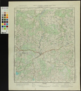
| Title | Eesti topograafiline kaart (1:50 000). Главное управление геодезии и картографии при Совете Министров СССР. Генерального штаба советской армии 0-35-79-Г (Вастселина) РСФСР Псков. обл. и Эстонская ССР |
|---|---|
| Map type | Single sheet map |
| Reference code | ERA.T-6.5.1 sheet 127 |
Notes
Salajane
Creators
| Firstname | Lastname | Occupation of cartographer | Creators position |
|---|---|---|---|
| Т. | Соколова | tehnik-kartograaf | cartographer |
Cartographical and Publishing Description
| Main subject | administrative |
|---|---|
| Material designaton | map |
| Manuscript/Printed | printed |
| Published by | VI 1952 |
| Base map(s) year | 1949 |
| Created | 1951 |
Components and Mathematical Description
| Components | grid lines, graphical scale |
|---|---|
| Azimuth | Not set |
| Relative scale | 50000 |
Geographical Description
| Admin unit | Specification |
|---|---|
| Estonia (1950-1991) / Vastseliina County (1950-1959) / Kapera Village Council (1945-1959) | |
| Estonia (1917-1950) / Võru County / Vastseliina Commune (1917-1950) | |
| other / Europe Continent / Eastern Europe Region / Russia |
Physical Description
| Storage form | streched |
|---|---|
| Material and mounting | paper |
| Medium | printed |
| Dimensions (cm) | 47x36/A2 |
| Access-restrictions | No access restriction |