Detailed description
To view the map area,
sign in or create account
sign in or create account
23.21 57.77, 25.78 58.86
Identity Description
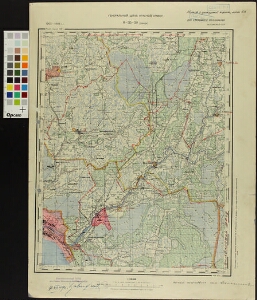
| Title | Eesti topograafiline kaart (1:100 000). Генеральный штаб РККА 0-35-50 (Синди) Эстонская ССР |
|---|---|
| Map type | Single sheet map |
| Reference code | ERA.T-6.5.3 sheet 40 |
Notes
Salajane
Creators
| Firstname | Lastname | Occupation of cartographer | Creators position |
|---|---|---|---|
| Borisova | kartograaf | cartographer |
Cartographical and Publishing Description
| Main subject | administrative |
|---|---|
| Material designaton | map |
| Manuscript/Printed | printed |
| Certified by | 7. VI. 1949 |
| Published by | VII 1941 |
| Base map(s) year | 1902-1906 |
| Created | 1939 |
Components and Mathematical Description
| Components | grid lines, graphical scale |
|---|---|
| Azimuth | Not set |
| Relative scale | 100000 |
Geographical Description
| Admin unit | Specification |
|---|---|
| Estonia (1917-1950) / Pärnu County | Pärnu, Sindi |
Physical Description
| Storage form | streched |
|---|---|
| Material and mounting | paper |
| Medium | printed |
| Dimensions (cm) | 47x34/A2 |
| Access-restrictions | No access restriction |