Detailed description
To view the map area,
sign in or create account
sign in or create account
21.79 57.51, 28.41 59.69
Identity Description
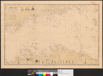
| Title | Soome laht Hoglandist Suurupini |
|---|---|
| Map type | Single sheet map |
| Reference code | ERA.496.4.261 sheet 50 |
Notes
Rannakaitse kava
Cartographical and Publishing Description
| Main subject | military |
|---|---|
| Material designaton | map |
| Manuscript/Printed | printed |
| Published by | Topograafia-Hüdrograafia Osakond, 1921 |
| Created | 1921 - 1927 |
Components and Mathematical Description
| Components | illustrated, grid lines |
|---|---|
| Azimuth | Not set |
| Textual scale | 1:193 395 |
| Relative scale | Not set |
Geographical Description
| Admin unit | Specification |
|---|---|
| Estonia (1917-1950) |
Physical Description
| Storage form | folder |
|---|---|
| Material and mounting | paper |
| Medium | printed+coloured |
| Dimensions (cm) | 64x95/A0 |
| Access-restrictions | No access restriction |