Detailed description
To view the map area,
sign in or create account
sign in or create account
26.91 57.66, 27.17 57.77
Identity Description
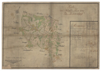
| Title | Karte von dem 1/2 Haaken Plaani unter Publ. Haanhoff. |
|---|---|
| Map type | Single sheet map |
| Reference code | EAA.308.6.257 sheet 1 |
Creators
| Firstname | Lastname | Occupation of cartographer | Creators position |
|---|---|---|---|
| Carl Christian | Anders | Tartu kreisimaamõõtja | cartographer |
Cartographical and Publishing Description
| Main subject | Not set |
|---|---|
| Material designaton | plan |
| Manuscript/Printed | manuscript original |
| Created | 1805 |
Components and Mathematical Description
| Components | explication, compass, graphical scale |
|---|---|
| Azimuth | 30 |
| Textual scale | Maasstab von 1000 Ellen Schwedische Landm. Maas = 11,7 cm |
| Relative scale | 5200 |
Geographical Description
| Admin unit | Specification |
|---|---|
| Estonia (to 1917) / Livonia Guberniya / Võru County / Rõuge Parish / Haanja Manor | Plaani |
Physical Description
| Storage form | streched |
|---|---|
| Material and mounting | paper+textile |
| Medium | ink+coloured |
| Dimensions (cm) | 73x50/A1 |
| Access-restrictions | No access restriction |