Detailed description
To view the map area,
sign in or create account
sign in or create account
26.10 59.28, 26.23 59.32
Identity Description
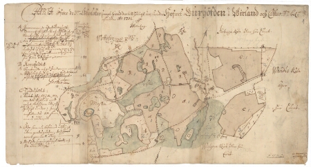
| Title | Charta öfwer dee 3:er åkerlotter sampt hwad der tillhörigt är, under Hofwet Buxhöfden i Wirland och Cathar[ina] So[chn] bel[eget] |
|---|---|
| Map type | Single sheet map |
| Reference code | EAA.1.2.C-IV-125 sheet 1 |
Notes
Mõisasüda, talukohad kujutatud punktidega, mõisa abihooned, kõrtsid pealt vaates; teedevõrk, aiad; mõisa külviväljad; vetevõrk, reljeef
Creators
| Firstname | Lastname | Occupation of cartographer | Creators position |
|---|---|---|---|
| Johan | Holmberg | maamõõtja | cartographer |
Cartographical and Publishing Description
| Main subject | Not set |
|---|---|
| Material designaton | plan |
| Manuscript/Printed | manuscript original |
| Created | 1702 |
Components and Mathematical Description
| Components | explication, compass |
|---|---|
| Azimuth | Not set |
| Textual scale | [Svenska alnar; 1500 = 11,1 cm] |
| Relative scale | 8250 |
Geographical Description
| Admin unit | Specification |
|---|---|
| Estonia (to 1917) / Estonia Guberniya / Viru County / Kadrina Parish / Neeruti Manor |
Physical Description
| Storage form | in binding |
|---|---|
| Material and mounting | paper |
| Medium | ink+coloured |
| Dimensions (cm) | 31x58/A2 |
| Access-restrictions | No access restriction |