Detailed description
To view the map area,
sign in or create account
sign in or create account
19.51 51.25, 32.74 70.08
Identity Description
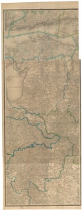
| Title | Специальня карта Западной части Россий Г. Л. Шуберта. Лист XII. |
|---|---|
| Map type | Subsheet |
| Reference code | EAA.46.2.348 sheet 6 |
Belongs to main sheet
EAA.46.2.348 sheet 1
Creators
| Firstname | Lastname | Occupation of cartographer | Creators position |
|---|---|---|---|
| G. L. | Schubert | cartographer |
Cartographical and Publishing Description
| Main subject | administrative |
|---|---|
| Material designaton | map |
| Manuscript/Printed | printed |
| Created | 1863 |
Components and Mathematical Description
| Components | legend for symbols, grid lines, compass, graphical scale |
|---|---|
| Azimuth | Not set |
| Textual scale | 1 toll = 10 versta |
| Relative scale | 420000 |
Geographical Description
| Admin unit | Specification |
|---|---|
| other / Europe Continent / Northern Europe Region / Finland | Lõuna-Soome |
| other / Europe Continent / Northern Europe Region / Latvia | |
| other / Europe Continent / Northern Europe Region / Lithuania | |
| other / Europe Continent / Eastern Europe Region / Belarus | |
| Estonia (to 1917) / Estonia Guberniya | |
| Estonia (to 1917) / Livonia Guberniya |
Physical Description
| Storage form | streched |
|---|---|
| Material and mounting | paper |
| Medium | printed+coloured |
| Dimensions (cm) | 200x81/4A0 |
| Access-restrictions | No access restriction |