Detailed description
To view the map area,
sign in or create account
sign in or create account
24.06006 57.75664, 25.42236 58.23120
Identity Description
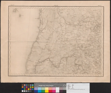
| Title | [Трехверстная карта Российской Империи]. Ряд 6, лист 4 |
|---|---|
| Map type | Single sheet map |
| Reference code | EAA.298.2.71 sheet 13 |
Notes
3-verstase kaardi leht
Cartographical and Publishing Description
| Main subject | Not set |
|---|---|
| Material designaton | map |
| Manuscript/Printed | printed |
| Created | 1855 - 1859 |
Components and Mathematical Description
| Components | grid lines, graphical scale |
|---|---|
| Azimuth | Not set |
| Textual scale | 6 versta = 7,4 cm |
| Relative scale | 126000 |
Geographical Description
| Admin unit | Specification |
|---|---|
| other / Europe Continent / Northern Europe Region / Latvia | |
| Estonia (to 1917) / Livonia Guberniya / Pärnu County / Tõstamaa Parish | Manilaid, Sorgu saar (Sorkholm) |
| Estonia (to 1917) / Livonia Guberniya / Pärnu County / Pärnu Elisabethi Parish | |
| Estonia (to 1917) / Livonia Guberniya / Viljandi County / Viljandi Parish | |
| Estonia (to 1917) / Livonia Guberniya / Pärnu County / Saarde Parish | Reiu jõgi, Ristiküla |
| Estonia (to 1917) / Livonia Guberniya / Pärnu County / Häädemeeste Parish |
Physical Description
| Storage form | folder |
|---|---|
| Material and mounting | paper |
| Medium | printed |
| Dimensions (cm) | 55x75/A1 |
| Access-restrictions | No access restriction |