Detailed description
To view the map area,
sign in or create account
sign in or create account
27.77344 41.47347, 28.40 82.06518
Identity Description
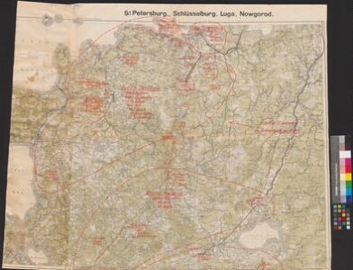
| Title | Übersichtskarte von Mitteleuropa. St. Petersburg, Schlüsselburg, Luga, Novgorod |
|---|---|
| Map type | Single sheet map |
| Reference code | ERA.2124.2.1086 sheet 14 |
Cartographical and Publishing Description
| Main subject | military |
|---|---|
| Material designaton | map |
| Manuscript/Printed | printed |
| Base map(s) year | 1915 |
| Created | 1918 |
Components and Mathematical Description
| Components | explication, grid lines |
|---|---|
| Azimuth | Not set |
| Relative scale | 300000 |
Geographical Description
| Admin unit | Specification |
|---|---|
| Estonia (1917-1950) / Viru County / Narva Commune (1938-1945) | |
| other / Europe Continent / Eastern Europe Region / Russia |
Physical Description
| Storage form | streched |
|---|---|
| Material and mounting | paper |
| Medium | printed+coloured |
| Dimensions (cm) | 158x93/2A0 |
| Access-restrictions | No access restriction |
Maps referring to this map
| Reference code | Manuscript/Printed |
|---|---|
| ERA.2124.2.1086 sheet 1 | printed |