Detailed description
To view the map area,
sign in or create account
sign in or create account
21.79 57.76, 23.44 58.68
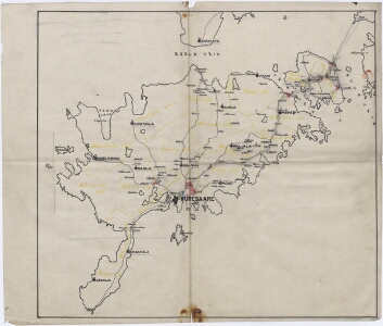
Identity Description
| Title | [Saaremaa] |
|---|---|
| Map type | Single sheet map |
| Reference code | ERA.2124.1.849 sheet 3 |
Cartographical and Publishing Description
| Main subject | administrative |
|---|---|
| Material designaton | map |
| Manuscript/Printed | manuscript rough draft |
| Created | 1920 (Estimated) |
Components and Mathematical Description
| Components | Not set |
|---|---|
| Azimuth | Not set |
| Relative scale | Not set |
Geographical Description
| Admin unit | Specification |
|---|---|
| Estonia (1917-1950) / Saare County |
Physical Description
| Storage form | in binding |
|---|---|
| Material and mounting | Tracing paper |
| Medium | ink+coloured |
| Dimensions (cm) | 33x40/A2 |
| Access-restrictions | No access restriction |
Maps referring to this map
| Reference code | Manuscript/Printed |
|---|---|
| ERA.2124.1.849 sheet 1 | printed |