Detailed description
To view the map area,
sign in or create account
sign in or create account
25.74 58.41, 26.36 58.83
Identity Description
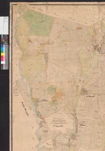
| Title | Charte von den im Livländischen Gouvernement Pernau Fellinschen Kreise und Oberpahlenschen Kirchspiele belegenen zum privaten Gute Neu Oberpahlen gehörigen Ländereien. Des Hofes, der Hoflage, Dörfer Allastfer, Pauastfer und Wöchma |
|---|---|
| Map type | Single sheet map |
| Reference code | EAA.1347.1.26 sheet 1 folio 1 |
Creators
| Firstname | Lastname | Occupation of cartographer | Creators position |
|---|---|---|---|
| Matthias | Fuchs | maamõõtja | land surveyor |
| August | Schultz | Liivimaa rüütelkonna maamõõtja | cartographer |
Cartographical and Publishing Description
| Main subject | Not set |
|---|---|
| Material designaton | plan |
| Manuscript/Printed | manuscript original |
| Created | 1862 |
Components and Mathematical Description
| Components | explication, legend for symbols, compass, graphical scale |
|---|---|
| Azimuth | Not set |
| Textual scale | 1300 küünart = 15 cm |
| Relative scale | 5200 |
Geographical Description
| Admin unit | Specification |
|---|---|
| Estonia (to 1917) / Livonia Guberniya / Viljandi County / Põltsamaa Parish | Põltsamaa, Pauastvere, Võhmanõmme, Mällikvere, Alastvere |
Physical Description
| Storage form | rolled |
|---|---|
| Material and mounting | paper+textile |
| Medium | ink+coloured |
| Dimensions (cm) | 195x147/4A0 |
| Access-restrictions | No access restriction |