Detailed description
To view the map area,
sign in or create account
sign in or create account
25.72517 57.90699, 25.81718 57.96915
Identity Description
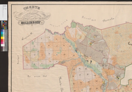
| Title | Charte von dem im Livländischen Gouvernement Fellinschen Kreise und Helmetschen Kirchspiele belegenen privaten Gute Hollershof. |
|---|---|
| Map type | Single sheet map |
| Reference code | EAA.2072.9.471 sheet 1 |
Creators
| Firstname | Lastname | Occupation of cartographer | Creators position |
|---|---|---|---|
| C. | Ruhs | rüütelkonna maamõõtja | land surveyor and cartographer |
Cartographical and Publishing Description
| Main subject | Not set |
|---|---|
| Material designaton | plan |
| Manuscript/Printed | manuscript original |
| Created | 1910 - 1912 |
Components and Mathematical Description
| Components | compass, graphical scale |
|---|---|
| Azimuth | 10 |
| Textual scale | 1300 küünart = 15,2 cm |
| Relative scale | 5200 |
Geographical Description
| Admin unit | Specification |
|---|---|
| Estonia (to 1917) / Livonia Guberniya / Viljandi County / Helme Parish / Holdre Manor | Holdre, Märdi järv, Lakesoo, Lasa järv |
NB! location is approximate
Physical Description
| Storage form | rolled |
|---|---|
| Material and mounting | paper+textile |
| Medium | ink+coloured |
| Dimensions (cm) | 177x146/4A0 |
| Access-restrictions | No access restriction |