Detailed description
To view the map area,
sign in or create account
sign in or create account
23.60 58.73, 28.20911 59.69
Identity Description
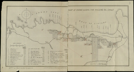
| Title | Map of concessions for raising oil shale |
|---|---|
| Map type | Single sheet map |
| Reference code | ERA.31.4.466 sheet 3 |
Cartographical and Publishing Description
| Main subject | other |
|---|---|
| Material designaton | plan |
| Manuscript/Printed | manuscript original |
| Created | 20. saj algus (Estimated) |
Components and Mathematical Description
| Components | explication, compass |
|---|---|
| Azimuth | Not set |
| Relative scale | 420000 |
Geographical Description
| Admin unit | Specification |
|---|---|
| Estonia (1917-1950) / Harju County | |
| Estonia (1917-1950) / Viru County / Rakvere Commune (1938-1950) | |
| Estonia (1917-1950) / Viru County / Kohtla Commune (1938-1950) | |
| Estonia (1917-1950) / Narva City/Town (1917-1950) |
Physical Description
| Storage form | folder |
|---|---|
| Material and mounting | paper |
| Medium | diazography+coloured |
| Dimensions (cm) | 29x54/A2 |
| Access-restrictions | No access restriction |