Detailed description
To view the map area,
sign in or create account
sign in or create account
14.94141 54.15214, 22.85156 56.68842
Identity Description
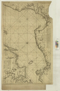
| Title | Nieuwe Paskaart voor een Gedeelte van de Oost-Zee [...] The New Sea Map of the First Part of the East-Sea [...] |
|---|---|
| Map type | Single sheet map |
| Reference code | LVVA.6828.4.29 sheet 1 |
Creators
| Firstname | Lastname | Occupation of cartographer | Creators position |
|---|---|---|---|
| Johannes | Keulen van | cartographer |
Cartographical and Publishing Description
| Main subject | hydrographic |
|---|---|
| Material designaton | map |
| Manuscript/Printed | printed |
| Published by | Gerard van Kaulen, 18.saj., Amsterdam |
| Created | 1728 (Estimated) |
Components and Mathematical Description
| Components | illustrated, compass, graphical scale |
|---|---|
| Azimuth | Not set |
| Relative scale | 700000 (Estimated) |
Physical Description
| Storage form | Not set |
|---|---|
| Material and mounting | paper |
| Medium | other |
| Dimensions (cm) | 63x101/A0 |
| Access-restrictions | Restrictions due to ownership |