Detailed description
To view the map area,
sign in or create account
sign in or create account
19.51 58.32, 31.58 70.08
Identity Description
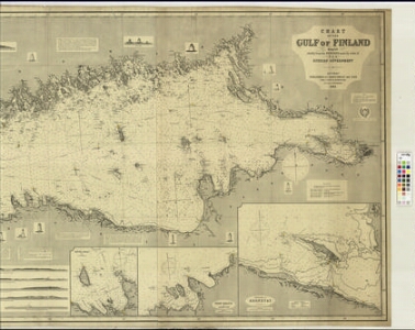
| Title | Chart of the Gulf of Finland complied chiefly from the surveys made by order of the Russian Government |
|---|---|
| Map type | Single sheet map |
| Reference code | LVVA.6828.4.44 sheet 1 |
Notes
Majakate kirjeldused, sadamad
Cartographical and Publishing Description
| Main subject | hydrographic |
|---|---|
| Material designaton | map |
| Manuscript/Printed | printed |
| Published by | James Imray & Son, 1883, London |
| Created | 1883 (Estimated) |
Components and Mathematical Description
| Components | illustrated, grid lines, compass, graphical scale |
|---|---|
| Azimuth | Not set |
| Relative scale | Not set |
Geographical Description
| Admin unit | Specification |
|---|---|
| Estonia (to 1917) / Estonia Guberniya | |
| other / Europe Continent / Northern Europe Region / Finland | Soome laht |
Physical Description
| Storage form | Not set |
|---|---|
| Material and mounting | paper |
| Medium | printed+coloured |
| Dimensions (cm) | 88x182/4A0 |
| Access-restrictions | Restrictions due to ownership |