Detailed description
To view the map area,
sign in or create account
sign in or create account
25.99 57.79, 27.44 59.06
Identity Description
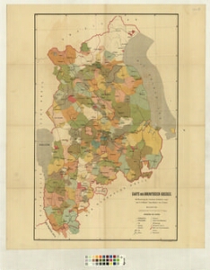
| Title | Karte des Dorpatschen Kreises |
|---|---|
| Map type | Single sheet map |
| Reference code | LVVA.6828.4.318 sheet 3 |
Creators
| Firstname | Lastname | Occupation of cartographer | Creators position |
|---|---|---|---|
| Carl Gottlieb | Rücker | author of base map |
Cartographical and Publishing Description
| Main subject | administrative |
|---|---|
| Material designaton | plan |
| Manuscript/Printed | printed |
| Published by | Картограф. Зав. А. Ильина |
| Created | 1877 (Estimated) |
Components and Mathematical Description
| Components | legend for symbols, grid lines, graphical scale |
|---|---|
| Azimuth | Not set |
| Textual scale | 8,7cm=15 versta |
| Relative scale | 184000 |
Geographical Description
| Admin unit | Specification |
|---|---|
| Estonia (to 1917) / Livonia Guberniya / Tartu County |
Physical Description
| Storage form | Not set |
|---|---|
| Material and mounting | paper |
| Medium | printed |
| Dimensions (cm) | Not set |
| Access-restrictions | Restrictions due to ownership |