Detailed description
To view the map area,
sign in or create account
sign in or create account
26.91 57.77, 27.09 57.85
Identity Description
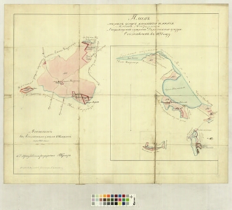
| Title | Плань мызныхь имъния Альт Казериць Лифляндской губернии Дерптскаго уъзда |
|---|---|
| Map type | Single sheet map |
| Reference code | LVVA.6828.4.392 sheet 1 |
Creators
| Firstname | Lastname | Occupation of cartographer | Creators position |
|---|---|---|---|
| P. | Krieger | land surveyor and cartographer | |
| K. | Olschevsky | vanem kroonumaamõõtja | land surveyor |
Cartographical and Publishing Description
| Main subject | Not set |
|---|---|
| Material designaton | plan |
| Manuscript/Printed | manuscript original |
| Created | 1871 |
Components and Mathematical Description
| Components | compass |
|---|---|
| Azimuth | Not set |
| Relative scale | 15552 |
Geographical Description
| Admin unit | Specification |
|---|---|
| Estonia (to 1917) / Livonia Guberniya / Võru County / Rõuge Parish / Vana Kasaritsa Manor |
Physical Description
| Storage form | Not set |
|---|---|
| Material and mounting | paper+textile |
| Medium | ink+coloured |
| Dimensions (cm) | 58x72/A1 |
| Access-restrictions | Restrictions due to ownership |