Detailed description
To view the map area,
sign in or create account
sign in or create account
26.04 57.94, 26.19 58.07
Identity Description
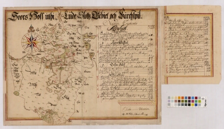
| Title | Soors Hoff uthi Lude Slottz Gebiet och Kirchspil |
|---|---|
| Map type | Single sheet map |
| Reference code | LVVA.7404.1.1427 sheet 1 |
Creators
| Firstname | Lastname | Occupation of cartographer | Creators position |
|---|---|---|---|
| Israel | Swedman | cartographer |
Cartographical and Publishing Description
| Main subject | Not set |
|---|---|
| Material designaton | plan |
| Manuscript/Printed | manuscript original |
| Created | 1689 |
Components and Mathematical Description
| Components | explication, compass |
|---|---|
| Azimuth | Not set |
| Textual scale | 1000 küünart = 11,6 cm |
| Relative scale | 10400 |
Geographical Description
| Admin unit | Specification |
|---|---|
| Estonia (to 1917) / Livonia Guberniya / Valga County / Lugazi Parish / Sooru Manor |
Physical Description
| Storage form | Not set |
|---|---|
| Material and mounting | paper |
| Medium | ink+coloured |
| Dimensions (cm) | 43x78/A1 |
| Access-restrictions | Restrictions due to ownership |