Detailed description
To view the map area,
sign in or create account
sign in or create account
25.57 57.85, 26.10 58.18
Identity Description
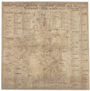
| Title | Geometrisch afritning öffwer Helmetz gebiet, medh dhes underliggiande adelige godz |
|---|---|
| Map type | Single sheet map |
| Reference code | EAA.308.2.191 sheet 1 |
Cartographical and Publishing Description
| Main subject | Not set |
|---|---|
| Material designaton | plan |
| Manuscript/Printed | manuscript original |
| Created | 1684 (Estimated) |
Components and Mathematical Description
| Components | explication, compass |
|---|---|
| Azimuth | Not set |
| Relative scale | 52000 (Estimated) |
Geographical Description
| Admin unit | Specification |
|---|---|
| Estonia (to 1917) / Livonia Guberniya / Viljandi County / Helme Parish | Helme, Leebiku, Vanamõisa, Patküla, Alamõisa, Aitsra, Koorküla, Kärstna, Tündre järv, Veisjärv |
Physical Description
| Storage form | rolled |
|---|---|
| Material and mounting | paper+textile |
| Medium | ink+coloured |
| Dimensions (cm) | 91x89/2A0 |
| Access-restrictions | No access restriction |