Detailed description
To view the map area,
sign in or create account
sign in or create account
24.82 59.31, 25.02 59.41
Identity Description
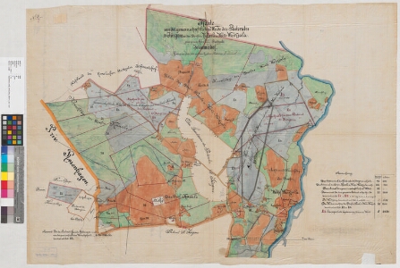
| Title | Karte von der gemeinschaftlichen Weide des Pastorates St. Jürgens und den Dörfern Kaarle und Weike-Waskjala, gehörig zum Revalschen Stadtgute Johannishof |
|---|---|
| Map type | Single sheet map |
| Reference code | EAA.854.4.128a sheet 1 |
Creators
| Firstname | Lastname | Occupation of cartographer | Creators position |
|---|---|---|---|
| Friedrich | Eurich | Tallinna linnamaamõõtja | cartographer |
Cartographical and Publishing Description
| Main subject | Not set |
|---|---|
| Material designaton | plan |
| Manuscript/Printed | manuscript original |
| Created | 1876 |
Components and Mathematical Description
| Components | explication, graphical scale |
|---|---|
| Azimuth | Not set |
| Textual scale | 300 sülda = 6 tolli |
| Relative scale | 4200 |
Geographical Description
| Admin unit | Specification |
|---|---|
| Estonia (to 1917) / Estonia Guberniya / Harju County / Jüri Parish / Rae Manor | Karla, Vaskjala |
Physical Description
| Storage form | streched |
|---|---|
| Material and mounting | tracing cloth |
| Medium | ink+coloured |
| Dimensions (cm) | 97x67/A0 |
| Access-restrictions | No access restriction |