Detailed description
To view the map area,
sign in or create account
sign in or create account
27.97119 59.27037, 28.25134 59.44117
Identity Description
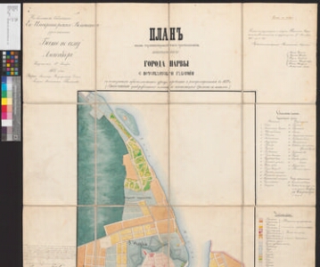
| Title | Планъ вновь проектированного расположения заштатного города Нарвы с Петербургской губернии. |
|---|---|
| Map type | Single sheet map |
| Reference code | EAA.1646.1.2728 sheet 1 |
Creators
| Firstname | Lastname | Occupation of cartographer | Creators position |
|---|---|---|---|
| Iv. | Lasukov | Uus-Laadoga kreisi maamõõtja | cartographer |
Cartographical and Publishing Description
| Main subject | town/borough |
|---|---|
| Material designaton | plan |
| Manuscript/Printed | manuscript copy |
| Certified by | Siseministeerium, 1875 |
| Base map(s) year | 1872 |
| Created | 1873 |
Components and Mathematical Description
| Components | explication, legend for symbols, graphical scale |
|---|---|
| Azimuth | Not set |
| Textual scale | 5 tolli = 50 sülda |
| Relative scale | 840 |
Geographical Description
| Admin unit | Specification |
|---|---|
| other / Europe Continent / Eastern Europe Region / Russia | Ivangorod |
| Estonia (to 1917) / Estonia Guberniya / Viru County / Narva City/Town (to 1917) |
NB! location is approximate
Physical Description
| Storage form | streched |
|---|---|
| Material and mounting | paper |
| Medium | ink+coloured |
| Dimensions (cm) | Not set |
| Access-restrictions | No access restriction |