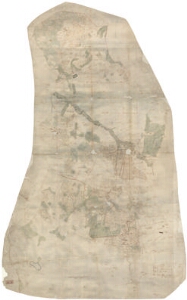
Detailed description
To view the map area,
sign in or create account
sign in or create account
24.89 59.01, 25.53 59.30
Identity Description
| Title | [Karta över Arrowall Hoff och Nyenhof] |
|---|---|
| Map type | Single sheet map |
| Reference code | EAA.1.2.C-IV-66 sheet 1 |
Creators
| Firstname | Lastname | Occupation of cartographer | Creators position |
|---|---|---|---|
| Johan | Holmberg | cartographer |
Cartographical and Publishing Description
| Main subject | Not set |
|---|---|
| Material designaton | plan |
| Manuscript/Printed | manuscript original |
| Created | 1696 |
Components and Mathematical Description
| Components | compass, graphical scale |
|---|---|
| Azimuth | 10 |
| Textual scale | 2000 küünart = 15 cm |
| Relative scale | 8200 |
Geographical Description
| Admin unit | Specification |
|---|---|
| Estonia (to 1917) / Estonia Guberniya / Harju County / Kose Parish | Aruvalla, Piuga, Mullikmäe, Ruskvere, Saula, Uuemõisa, Kolu, Kanavere, Kurena, Karla, Leva, Kirimäe, Leva järv |
Physical Description
| Storage form | rolled |
|---|---|
| Material and mounting | paper |
| Medium | ink+coloured |
| Dimensions (cm) | 213x112/4A0 |
| Access-restrictions | No access restriction |