Detailed description
To view the map area,
sign in or create account
sign in or create account
25.62012 59.34327, 29.79492 60.26525
Identity Description
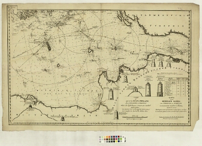
| Title | Карта части Финскаго залива оть Стеншера до Кронштата сь означениемь маяковь и башень. Chart of part of the Gulf of Finnland from the Stoneskar to Cronstadt where the light houses & towers are marked |
|---|---|
| Map type | Subsheet |
| Reference code | LVVA.6828.4.41 sheet 2 |
Belongs to main sheet
LVVA.6828.4.41 sheet 1
Notes
Majakate asukohad ja joonised; Lobineem-Kroonlinn
Cartographical and Publishing Description
| Main subject | hydrographic |
|---|---|
| Material designaton | plan |
| Manuscript/Printed | printed |
| Created | 19. saj algus (Estimated) |
Components and Mathematical Description
| Components | illustrated, compass, graphical scale |
|---|---|
| Azimuth | Not set |
| Relative scale | 82000 (Estimated) |
Physical Description
| Storage form | Not set |
|---|---|
| Material and mounting | paper |
| Medium | printed |
| Dimensions (cm) | 66x100/A0 |
| Access-restrictions | Restrictions due to ownership |