Detailed description
To view the map area,
sign in or create account
sign in or create account
27.03667 57.79571, 27.14584 57.83667
Identity Description
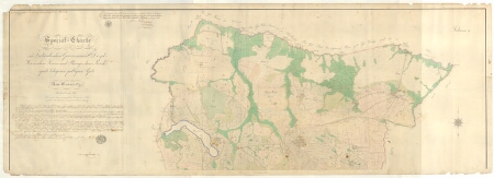
| Title | Special-Charte von dem im Livländischen Gouvernement, Dörpt-Werroschen Kreise und Raugeschen Kirchspiele belegenen publiquen Gute Neu-Casseritz. |
|---|---|
| Map type | Multiple-sheet map |
| Reference code | EAA.2072.3.57b sheet 1 folio I |
Subsheets
| Reference code |
|---|
| EAA.2072.3.57b sheet 2 folio II |
| EAA.2072.3.57b sheet 3 folio III |
Creators
| Firstname | Lastname | Occupation of cartographer | Creators position |
|---|---|---|---|
| Gustav | Bernhoff | vannutatud maamõõtja | land surveyor and cartographer |
Cartographical and Publishing Description
| Main subject | Not set |
|---|---|
| Material designaton | plan |
| Manuscript/Printed | manuscript original |
| Certified by | Liivimaa maamõõdu- ja revisjonikomisjon, 23.08.1851 |
| Created | 1850 |
Components and Mathematical Description
| Components | compass |
|---|---|
| Azimuth | Not set |
| Relative scale | 5200 |
Geographical Description
| Admin unit | Specification |
|---|---|
| Estonia (to 1917) / Livonia Guberniya / Võru County / Rõuge Parish / Vastse Kasaritsa Manor | Verijärv, Palometsa, Holopi, Sibula |
NB! location is approximate
Physical Description
| Storage form | rolled |
|---|---|
| Material and mounting | paper |
| Medium | ink+coloured |
| Dimensions (cm) | 207x75/4A0 |
| Access-restrictions | No access restriction |
Documents of description
| Reference code | Title | Creator | Year |
|---|---|---|---|
| EAA.186.3.66-67 | Revisorische Beschreibung | 1850 |
Maps referred to by this map
| Reference code | Relation |
|---|---|
| EAA.2072.3.57a sheet 1 | rough draft |
Maps referring to this map
| Reference code | Manuscript/Printed |
|---|---|
| EAA.2072.3.57a sheet 1 folio I | manuscript rough draft |