Detailed description
To view the map area,
sign in or create account
sign in or create account
21.79 57.51, 28.41 59.69
Identity Description
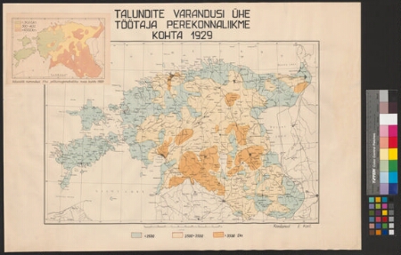
| Title | Talundite varandusi ühe töötaja perekonnaliikme kohta 1929 |
|---|---|
| Map type | Single sheet map |
| Reference code | ERA.4420.1.137 sheet 1 |
Creators
| Firstname | Lastname | Occupation of cartographer | Creators position |
|---|---|---|---|
| E. | Kant | cartographer |
Cartographical and Publishing Description
| Main subject | demographic |
|---|---|
| Material designaton | map |
| Manuscript/Printed | printed |
| Created | 1929 |
Components and Mathematical Description
| Components | legend for symbols, graphical scale |
|---|---|
| Azimuth | Not set |
| Relative scale | 750000 |
Geographical Description
| Admin unit | Specification |
|---|---|
| Estonia (1917-1950) |
Physical Description
| Storage form | ümbrik |
|---|---|
| Material and mounting | paper |
| Medium | printed+coloured |
| Dimensions (cm) | 49x70/A1 |
| Access-restrictions | No access restriction |