Detailed description
To view the map area,
sign in or create account
sign in or create account
24.95 57.85, 26.36 58.83
Identity Description
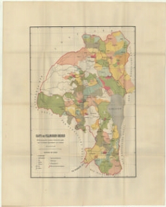
| Title | Karte des Fellinschen Kreises |
|---|---|
| Map type | Multiple-sheet map |
| Reference code | EAA.1809.2.296 sheet 1 |
Creators
| Firstname | Lastname | Occupation of cartographer | Creators position |
|---|---|---|---|
| C. G. | Rücker | author of base map |
Cartographical and Publishing Description
| Main subject | Not set |
|---|---|
| Material designaton | map |
| Manuscript/Printed | printed |
| Created | 1900 (Estimated) |
Components and Mathematical Description
| Components | legend for symbols, grid lines, graphical scale |
|---|---|
| Azimuth | Not set |
| Textual scale | Maasstab 15 Werst = 8,7 cm |
| Relative scale | 184000 |
Geographical Description
| Admin unit | Specification |
|---|---|
| Estonia (to 1917) / Livonia Guberniya / Viljandi County |
Physical Description
| Storage form | streched |
|---|---|
| Material and mounting | paper |
| Medium | printed |
| Dimensions (cm) | 84x67/A0 |
| Access-restrictions | No access restriction |