Detailed description
To view the map area,
sign in or create account
sign in or create account
26.44 57.63, 26.68 57.86
Identity Description
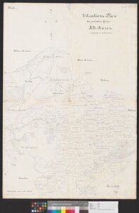
| Title | Situations-Plan des privaten Gutes Alt-Anzen |
|---|---|
| Map type | Multiple-sheet map |
| Reference code | EAA.3724.5.2893 sheet 1 |
Subsheets
| Reference code |
|---|
| EAA.3724.5.2893 sheet 2 |
| EAA.3724.5.2893 sheet 3 |
Creators
| Firstname | Lastname | Occupation of cartographer | Creators position |
|---|---|---|---|
| Eduard | Drommert | cartographer |
Cartographical and Publishing Description
| Main subject | Not set |
|---|---|
| Material designaton | plan |
| Manuscript/Printed | manuscript original |
| Created | 1900 (Estimated) |
Components and Mathematical Description
| Components | legend for symbols, compass, graphical scale |
|---|---|
| Azimuth | Not set |
| Relative scale | 21000 |
Geographical Description
| Admin unit | Specification |
|---|---|
| Estonia (to 1917) / Livonia Guberniya / Võru County / Urvaste Parish / Vana Antsla Manor |
Physical Description
| Storage form | streched |
|---|---|
| Material and mounting | paper |
| Medium | ink |
| Dimensions (cm) | 98x67/A0 |
| Access-restrictions | No access restriction |