Detailed description
To view the map area,
sign in or create account
sign in or create account
26.56303 56.85363, 28.23000 58.22000
Identity Description
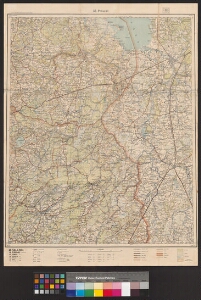
| Title | [Eesti topograafiline ülevaatekaart. Lehed:] 35-Petseri |
|---|---|
| Map type | Subsheet |
| Reference code | EAA.5392.1.235 sheet 3 |
Belongs to main sheet
EAA.5392.1.235 sheet 1
Notes
Kaardil on osaliselt Lätit (kuni Balupe jõeni, Balvi asulani). Kaart on "Kv. St. Topo-Hüdrograafia osakonna väljaanne 1933 a."
Cartographical and Publishing Description
| Main subject | Not set |
|---|---|
| Material designaton | map |
| Manuscript/Printed | printed |
| Published by | Riigi Trükikoda, 1935 |
| Created | 1935 |
Components and Mathematical Description
| Components | legend for symbols, grid lines, graphical scale |
|---|---|
| Azimuth | Not set |
| Relative scale | 200000 |
Geographical Description
| Admin unit | Specification |
|---|---|
| Estonia (1917-1950) / Petseri County (1919-1944) | Petseri mk |
| Estonia (1917-1950) / Võru County | |
| other / Europe Continent / Northern Europe Region / Latvia |
Physical Description
| Storage form | streched |
|---|---|
| Material and mounting | paper |
| Medium | printed+coloured |
| Dimensions (cm) | 66x48/A1 |
| Access-restrictions | No access restriction |