Detailed description
To view the map area,
sign in or create account
sign in or create account
21.35551 57.20043, 24.49465 58.59501
Identity Description
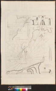
| Title | [Часть Острова Эзеля. Южный мысъ Острова Эзеля./ Part of the Island of Esel.] |
|---|---|
| Map type | Subsheet |
| Reference code | EAA.1414.2.35 sheet 10 |
Belongs to main sheet
EAA.1414.2.35 sheet 1a
Notes
Majakate profiilide joonised.
Creators
| Firstname | Lastname | Occupation of cartographer | Creators position |
|---|---|---|---|
| Leonti | Spavarijev | kindralmajor | cartographer |
Cartographical and Publishing Description
| Main subject | hydrographic |
|---|---|
| Material designaton | map |
| Manuscript/Printed | printed |
| Published by | Mereväe trükikoda, 1823, St. Peterburg |
| Created | 1823 |
Components and Mathematical Description
| Components | illustrated, compass, graphical scale |
|---|---|
| Azimuth | 13 |
| Textual scale | erinevad mõõtkavad |
| Relative scale | Not set |
Geographical Description
| Admin unit | Specification |
|---|---|
| other / Europe Continent / Northern Europe Region / Latvia | Kolka |
| Estonia (to 1917) / Livonia Guberniya | Saaremaa |
NB! location is approximate
Physical Description
| Storage form | atlas |
|---|---|
| Material and mounting | paper |
| Medium | ink |
| Dimensions (cm) | 66x98/A0 |
| Access-restrictions | No access restriction |