Detailed description
To view the map area,
sign in or create account
sign in or create account
26.98 58.55, 27.22 58.68
Identity Description
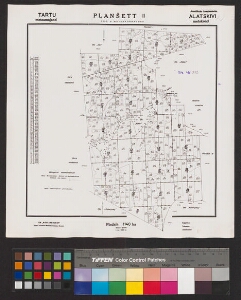
| Title | Tartu metsamajand. Alatskivi metskond. |
|---|---|
| Map type | Subsheet |
| Reference code | EAA.T-1089.2.20 sheet 2 |
Belongs to main sheet
EAA.T-1089.2.20 sheet 1
Cartographical and Publishing Description
| Main subject | forestry map |
|---|---|
| Material designaton | plan |
| Manuscript/Printed | printed |
| Created | 1962 |
Components and Mathematical Description
| Components | compass |
|---|---|
| Azimuth | Not set |
| Textual scale | Mõõt 1:20000. 1 sm = 200 m. |
| Relative scale | 20000 |
Geographical Description
| Admin unit | Specification |
|---|---|
| Estonia (1950-1991) / Tartu County (1950-1991) / Alatskivi Village Council (1959-1991) | Alatskivi metskond |
Physical Description
| Storage form | streched |
|---|---|
| Material and mounting | paper |
| Medium | printed |
| Dimensions (cm) | Not set |
| Access-restrictions | No access restriction |