Detailed description
To view the map area,
sign in or create account
sign in or create account
28.17478 59.35855, 28.20705 59.39163
Identity Description
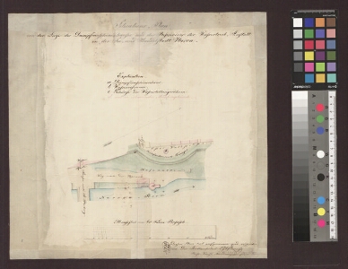
| Title | Situations "Plan von der Lage des Dampfmaschinenhauses und des Reservoires des Wassertreib "Anstalt in der See" und Handelstadt Narva. |
|---|---|
| Map type | Single sheet map |
| Reference code | EAA.1646.1.2722 sheet 1 |
Cartographical and Publishing Description
| Main subject | Not set |
|---|---|
| Material designaton | plan |
| Manuscript/Printed | manuscript original |
| Created | 1866 |
Components and Mathematical Description
| Components | explication, compass, graphical scale |
|---|---|
| Azimuth | 70 |
| Textual scale | Maasstab von 60 Faden Russisch = 15,3cm |
| Relative scale | 840 |
Geographical Description
| Admin unit | Specification |
|---|---|
| Estonia (to 1917) / Estonia Guberniya / Viru County / Narva City/Town (to 1917) | Narva jõgi, Peterburi mnt |
Physical Description
| Storage form | streched |
|---|---|
| Material and mounting | paper |
| Medium | ink+coloured |
| Dimensions (cm) | 34x36/A2 |
| Access-restrictions | No access restriction |