Detailed description
To view the map area,
sign in or create account
sign in or create account
28.10852 59.23695, 28.28979 59.42887
Identity Description
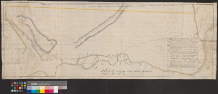
| Title | Планъ имеющемуся на иванегородском варштате военно людей строения с прожектому. |
|---|---|
| Map type | Single sheet map |
| Reference code | EAA.1646.1.2921 sheet 3 |
Cartographical and Publishing Description
| Main subject | Not set |
|---|---|
| Material designaton | plan |
| Manuscript/Printed | manuscript original |
| Created | 1747 |
Components and Mathematical Description
| Components | explication, compass, graphical scale |
|---|---|
| Azimuth | 220 |
| Textual scale | 1 inglise toll = 100 sülda |
| Relative scale | 8400 |
Geographical Description
| Admin unit | Specification |
|---|---|
| other / Europe Continent / Eastern Europe Region / Russia | Ivangorod |
| Estonia (to 1917) / Estonia Guberniya / Viru County / Narva City/Town (to 1917) | Narva jõgi |
Physical Description
| Storage form | streched |
|---|---|
| Material and mounting | paper |
| Medium | ink+coloured |
| Dimensions (cm) | 40x110/A0 |
| Access-restrictions | No access restriction |