Detailed description
To view the map area,
sign in or create account
sign in or create account
28.03711 58.98738, 28.88306 59.55993
Identity Description
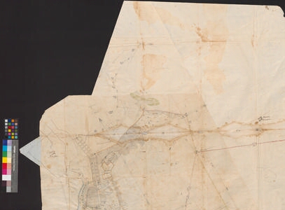
| Title | Планъ состоящей въ Санкть Петербургском Губернии въ Нарвскомъ уезде, блйзъ Города Нврвы Новой Деревни. |
|---|---|
| Map type | Multiple-sheet map |
| Reference code | EAA.1646.1.2921 sheet 1 |
Subsheets
| Reference code |
|---|
| EAA.1646.1.2921 sheet 1p |
Creators
| Firstname | Lastname | Occupation of cartographer | Creators position |
|---|---|---|---|
| Johann | Mandelin | Narva kreisimaamõõtja | land surveyor and cartographer |
Cartographical and Publishing Description
| Main subject | Not set |
|---|---|
| Material designaton | plan |
| Manuscript/Printed | manuscript original |
| Created | 1783 |
Components and Mathematical Description
| Components | explication, compass, graphical scale |
|---|---|
| Azimuth | 310 |
| Textual scale | 1 inglise toll = 100 sülda |
| Relative scale | 8400 |
Geographical Description
| Admin unit | Specification |
|---|---|
| other / Europe Continent / Eastern Europe Region / Russia | Peterburi kubermang, Novaja derevnje, Komarovka, Lilienbach, Pljussa jõgi |
| Estonia (to 1917) / Estonia Guberniya / Viru County / Narva City/Town (to 1917) | Narva jõgi |
Physical Description
| Storage form | streched |
|---|---|
| Material and mounting | paper |
| Medium | ink+coloured |
| Dimensions (cm) | 141x125/4A0 |
| Access-restrictions | No access restriction |