Detailed description
To view the map area,
sign in or create account
sign in or create account
24.94 59.0550, 24.96 59.0650
Identity Description
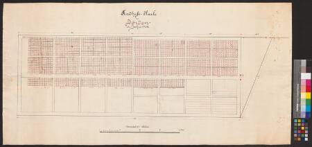
| Title | Friedhofs-Karte zu Jörden im Jahre 1905. |
|---|---|
| Map type | Single sheet map |
| Reference code | EAA.1211.1.159 sheet 1 |
Cartographical and Publishing Description
| Main subject | Not set |
|---|---|
| Material designaton | plan |
| Manuscript/Printed | manuscript original |
| Created | 1905 |
Components and Mathematical Description
| Components | graphical scale |
|---|---|
| Azimuth | Not set |
| Textual scale | 7 mm = 1 süld |
| Relative scale | 300 |
Geographical Description
| Admin unit | Specification |
|---|---|
| Estonia (to 1917) / Estonia Guberniya / Harju County / Juuru Parish / Juuru Commune (1866-1917) | Juuru evangeelse luteriusu koguduse kalmistu |
Physical Description
| Storage form | streched |
|---|---|
| Material and mounting | paper |
| Medium | ink |
| Dimensions (cm) | Not set |
| Access-restrictions | No access restriction |