Detailed description
To view the map area,
sign in or create account
sign in or create account
26.16 57.91, 26.33 57.98
Identity Description
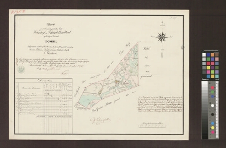
| Title | Charte von dem zum privaten Gute Koenhof-Charlottenthal gehörigen Gesinde Lombi |
|---|---|
| Map type | Multiple-sheet map |
| Reference code | EAA.2469.1.10035 sheet 10 |
Creators
| Firstname | Lastname | Occupation of cartographer | Creators position |
|---|---|---|---|
| E. | Christiani | Pärnu-Viljandi kreisimaamõõtja, titulaarnõunik | cartographer |
Cartographical and Publishing Description
| Main subject | farm map |
|---|---|
| Material designaton | plan |
| Manuscript/Printed | manuscript original |
| Created | 1861 |
Components and Mathematical Description
| Components | explication, compass, graphical scale |
|---|---|
| Azimuth | Not set |
| Textual scale | 9,4 cm = 800 küünar |
| Relative scale | 5020 |
Geographical Description
| Admin unit | Specification |
|---|---|
| Estonia (to 1917) / Livonia Guberniya / Tartu County / Sangaste Parish / Keeni Manor | Keeni-Lota |
Physical Description
| Storage form | folder |
|---|---|
| Material and mounting | paper |
| Medium | ink+coloured |
| Dimensions (cm) | 46x64/A1 |
| Access-restrictions | No access restriction |