Detailed description
To view the map area,
sign in or create account
sign in or create account
26.11622 59.20962, 26.28582 59.29212
Identity Description
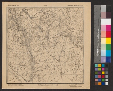
| Title | [Топографическая 1-верстная карта России. Эстлянд. губ. Везенб. и Вейссенштейн.уезд. Лист 5-36/ Vene topograafide aastatel 1893-1913 mõõdistatud 1-verstane kaart. |
|---|---|
| Map type | Subsheet |
| Reference code | EAA.854.4.27a sheet 68 |
Belongs to main sheet
EAA.854.4.27a sheet 1
Cartographical and Publishing Description
| Main subject | Not set |
|---|---|
| Material designaton | map |
| Manuscript/Printed | printed |
| Created | 1897 |
Components and Mathematical Description
| Components | graphical scale |
|---|---|
| Azimuth | Not set |
| Textual scale | 1:42 000 |
| Relative scale | 42000 |
Geographical Description
| Admin unit | Specification |
|---|---|
| Estonia (to 1917) / Estonia Guberniya / Viru County / Kadrina Parish / Lasila Manor | |
| Estonia (to 1917) / Estonia Guberniya / Viru County / Väike Maarja Parish / Karunga Manor | |
| Estonia (to 1917) / Estonia Guberniya / Järva County / Ambla Parish / Järvajõe Manor | |
| Estonia (to 1917) / Estonia Guberniya / Viru County / Väike Maarja Parish / Kullenga Manor |
Physical Description
| Storage form | in box |
|---|---|
| Material and mounting | paper |
| Medium | printed |
| Dimensions (cm) | 35x37/A2 |
| Access-restrictions | No access restriction |