Detailed description
To view the map area,
sign in or create account
sign in or create account
24.17 59.20, 24.72 59.60
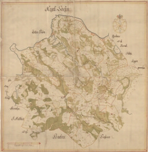
Identity Description
| Title | Kegell Sochn |
|---|---|
| Map type | Single sheet map |
| Reference code | EAA.1.2.C-II-4 sheet 1 |
Notes
Stiliseeritud leppemärkidega eristatud mõisasüdamed, veskid, kirikud, kirikumõisad, talukohad kujutatud punktidena; mõisate piirid ja piiripunktid; teedevõrk; vetevõrk, rannajoon (Kloogaranna kuni Harku oja), reljeefselt kujutatud pankrannik ja väiksemad künkad; illustreeritud kompass-roos, graafiline mõõtkava
Cartographical and Publishing Description
| Main subject | Not set |
|---|---|
| Material designaton | plan |
| Manuscript/Printed | manuscript original |
| Created | 17. saj II pool |
Components and Mathematical Description
| Components | compass, graphical scale |
|---|---|
| Azimuth | Not set |
| Textual scale | LiJffländer Mijl a 12000 S: Alnar |
| Relative scale | 40000 |
Geographical Description
| Admin unit | Specification |
|---|---|
| Estonia (to 1917) / Estonia Guberniya / Harju County / Keila Parish |
Physical Description
| Storage form | streched |
|---|---|
| Material and mounting | paper+textile |
| Medium | ink+coloured |
| Dimensions (cm) | 86x84/A0 |
| Access-restrictions | No access restriction |