Detailed description
To view the map area,
sign in or create account
sign in or create account
28.15624 59.35768, 28.20911 59.39198
Identity Description
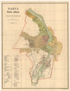
| Title | Narva linna plaan |
|---|---|
| Map type | Single sheet map |
| Reference code | EAA.2110.1.4813 sheet 1 |
Creators
| Firstname | Lastname | Occupation of cartographer | Creators position |
|---|---|---|---|
| F. | Kabanov | Narva linna maamõõtja | cartographer |
Cartographical and Publishing Description
| Main subject | Not set |
|---|---|
| Material designaton | plan |
| Manuscript/Printed | printed |
| Published by | Eesti Kirjastus-Ühisuse kiwitrükk, 1929, Tallinn |
| Created | 1927 |
Components and Mathematical Description
| Components | explication, grid lines, compass, graphical scale |
|---|---|
| Azimuth | Not set |
| Textual scale | Mõõt 1: 10000 |
| Relative scale | 10000 |
Geographical Description
| Admin unit | Specification |
|---|---|
| Estonia (1917-1950) / Narva City/Town (1917-1950) | Narva |
Physical Description
| Storage form | folder |
|---|---|
| Material and mounting | paper |
| Medium | printed+coloured |
| Dimensions (cm) | 91x71/A0 |
| Access-restrictions | No access restriction |