Detailed description
To view the map area,
sign in or create account
sign in or create account
23.50594 58.93965, 23.55658 58.96310
Identity Description
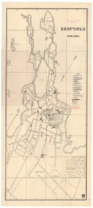
| Title | Haapsalu linna plaan |
|---|---|
| Map type | Single sheet map |
| Reference code | EAA.2110.1.4811 sheet 6 |
Cartographical and Publishing Description
| Main subject | Not set |
|---|---|
| Material designaton | plan |
| Manuscript/Printed | printed |
| Created | 1925 |
Components and Mathematical Description
| Components | explication, legend for symbols, compass, graphical scale |
|---|---|
| Azimuth | 30 |
| Textual scale | [1: 6300] |
| Relative scale | Not set |
Geographical Description
| Admin unit | Specification |
|---|---|
| Estonia (1917-1950) / Haapsalu City/Town (1917-1950) | Haapsalu |
Physical Description
| Storage form | other |
|---|---|
| Material and mounting | paper |
| Medium | printed |
| Dimensions (cm) | 69x30/A1 |
| Access-restrictions | No access restriction |