Detailed description
To view the map area,
sign in or create account
sign in or create account
26.80 57.91, 26.96 58
Identity Description
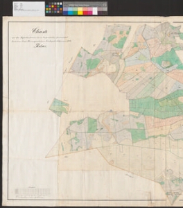
| Title | Charte von den Hofesländereien des im Livlandischen Gouvernement Werroschen Kreise Kannapaeschen Kirchspiele belegenen prv. Gutes Poelks |
|---|---|
| Map type | Single sheet map |
| Reference code | EAA.2469.1.747 sheet 1 |
Creators
| Firstname | Lastname | Occupation of cartographer | Creators position |
|---|---|---|---|
| Leopold | Intelmann | rüütelkonna maamõõtja | cartographer |
Cartographical and Publishing Description
| Main subject | Not set |
|---|---|
| Material designaton | plan |
| Manuscript/Printed | manuscript copy |
| Created | 1897 |
Components and Mathematical Description
| Components | compass, graphical scale |
|---|---|
| Azimuth | 30 |
| Textual scale | Maassstab 1200 Ellen = 14.1 cm |
| Relative scale | 5200 |
Geographical Description
| Admin unit | Specification |
|---|---|
| Estonia (to 1917) / Livonia Guberniya / Võru County / Kanepi Parish / Põlgaste Manor |
Physical Description
| Storage form | folder |
|---|---|
| Material and mounting | paper |
| Medium | ink+coloured |
| Dimensions (cm) | 87x150/2A0 |
| Access-restrictions | No access restriction |