Detailed description
To view the map area,
sign in or create account
sign in or create account
25.62 58.68, 25.93 58.80
Identity Description
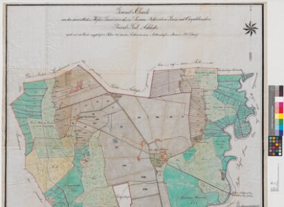
| Title | General-Charte von dem sämmtlichen Hofes-Ländereien des im Pernau-Fellinschen Kreise und Oberpahlenschen Privat-Gut Addaffer |
|---|---|
| Map type | Single sheet map |
| Reference code | EAA.2469.1.703 sheet 1 |
Creators
| Firstname | Lastname | Occupation of cartographer | Creators position |
|---|---|---|---|
| J. F. | Seeland | rüütelkonna maamõõtja | cartographer |
Cartographical and Publishing Description
| Main subject | Not set |
|---|---|
| Material designaton | plan |
| Manuscript/Printed | manuscript copy |
| Created | 1887 |
Components and Mathematical Description
| Components | compass, graphical scale |
|---|---|
| Azimuth | Not set |
| Textual scale | Maasstab von 1300 Ellen = 15 cm |
| Relative scale | 5200 |
Geographical Description
| Admin unit | Specification |
|---|---|
| Estonia (to 1917) / Livonia Guberniya / Viljandi County / Põltsamaa Parish / Adavere Manor |
Physical Description
| Storage form | folder |
|---|---|
| Material and mounting | tracing cloth |
| Medium | ink+coloured |
| Dimensions (cm) | 119x104/2A0 |
| Access-restrictions | No access restriction |