Detailed description
To view the map area,
sign in or create account
sign in or create account
27.26 57.89, 27.56 58.21
Identity Description
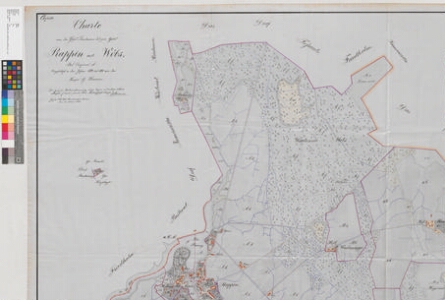
| Title | Charte von den Hofes Ländereien des privat Gutes Rappin mit Wöbs |
|---|---|
| Map type | Single sheet map |
| Reference code | EAA.2469.1.761 sheet 3 |
Creators
| Firstname | Lastname | Occupation of cartographer | Creators position |
|---|---|---|---|
| C. | Brauer | rüütelkonna maamõõtja | cartographer |
| H. | Hermson | author of base map |
Cartographical and Publishing Description
| Main subject | Not set |
|---|---|
| Material designaton | plan |
| Manuscript/Printed | manuscript copy |
| Base map(s) year | 1882, 1883 |
| Created | 1903 |
Components and Mathematical Description
| Components | compass, graphical scale |
|---|---|
| Azimuth | 350 |
| Textual scale | Maasstab von 1300 Ellen = 15,2 cm |
| Relative scale | 5200 |
Geographical Description
| Admin unit | Specification |
|---|---|
| Estonia (to 1917) / Livonia Guberniya / Võru County / Räpina Parish / Räpina Manor |
Physical Description
| Storage form | folder |
|---|---|
| Material and mounting | tracing cloth |
| Medium | ink+coloured |
| Dimensions (cm) | 139x198/4A0 |
| Access-restrictions | No access restriction |