Detailed description
To view the map area,
sign in or create account
sign in or create account
26.78 58.04, 26.93 58.10
Identity Description
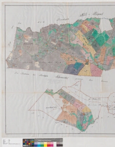
| Title | Charte von dem im Livländischen Gouvernement, Werroschen Kreise und Kannapähschen Kirchspiele belegenen privaten Gute Koellitz |
|---|---|
| Map type | Single sheet map |
| Reference code | EAA.2469.1.744 sheet 1 |
Creators
| Firstname | Lastname | Occupation of cartographer | Creators position |
|---|---|---|---|
| Ernst Friedrich | Fedder | cartographer | |
| Woldemar Carl | Breyer | author of base map |
Cartographical and Publishing Description
| Main subject | Not set |
|---|---|
| Material designaton | plan |
| Manuscript/Printed | manuscript copy |
| Base map(s) year | 1883 |
| Created | 1888 |
Components and Mathematical Description
| Components | explication, compass, graphical scale |
|---|---|
| Azimuth | 20 |
| Textual scale | Maasstab von 1300 Ellen = 15,1 cm |
| Relative scale | 5200 |
Geographical Description
| Admin unit | Specification |
|---|---|
| Estonia (to 1917) / Livonia Guberniya / Võru County / Kanepi Parish / Krootuse Manor |
Physical Description
| Storage form | folder |
|---|---|
| Material and mounting | tracing cloth |
| Medium | ink+coloured |
| Dimensions (cm) | 95x187/4A0 |
| Access-restrictions | No access restriction |