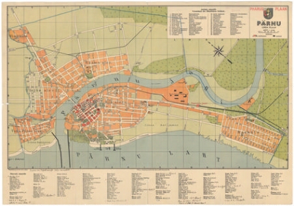
Detailed description
To view the map area,
sign in or create account
sign in or create account
24.46724 58.37380, 24.53625 58.39612
Identity Description
| Title | Pharus plaan. Pärnu linna plaan. |
|---|---|
| Map type | Single sheet map |
| Reference code | EAA.2110.1.4818 sheet 3 |
Creators
| Firstname | Lastname | Occupation of cartographer | Creators position |
|---|---|---|---|
| Cornelius | Löwe | cartographer |
Cartographical and Publishing Description
| Main subject | Not set |
|---|---|
| Material designaton | plan |
| Manuscript/Printed | printed |
| Created | 1930 (Estimated) |
Components and Mathematical Description
| Components | explication, legend for symbols, compass, graphical scale |
|---|---|
| Azimuth | 330 |
| Textual scale | Mõõt 1:15 000 |
| Relative scale | 15000 |
Geographical Description
| Admin unit | Specification |
|---|---|
| Estonia (to 1917) / Livonia Guberniya / Pärnu County / Pärnu City/Town (1251-1917) | Pärnu |
Physical Description
| Storage form | folder |
|---|---|
| Material and mounting | paper |
| Medium | printed |
| Dimensions (cm) | 42x61/A1 |
| Access-restrictions | No access restriction |
Maps referred to by this map
| Reference code | Relation |
|---|---|
| EAA.2072.9.839 sheet 1 | |
| EAA.2072.9.939 sheet 2 |
Maps referring to this map
| Reference code | Manuscript/Printed |
|---|---|
| EAA.2072.9.839 sheet 1 | printed |
| EAA.2072.9.839 sheet 2 | printed |