Detailed description
To view the map area,
sign in or create account
sign in or create account
28.17478 59.35855, 28.20705 59.39163
Identity Description
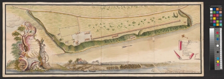
| Title | Plan und Charte von der Reeperbahn, samt ihrer und der anstoszenden Grenze von Rotenhahn und Marienhoff |
|---|---|
| Map type | Single sheet map |
| Reference code | EAA.3249.1.4 sheet 1 |
Notes
Asustus on plaanil toodud nii pealtvaates kui ka perspektiivis, püütud jälgida hoonete välisilmet; stiliseeritud leppemärkidega majad, tall; mõisa piir, tee piir; teedevõrk, maantee, külatee, tänav (Seemündsche strasse), sillad, paadisild; vetevõrk; kaunistatud pealkirjaraam ja kompassroos.
Cartographical and Publishing Description
| Main subject | Not set |
|---|---|
| Material designaton | plan |
| Manuscript/Printed | manuscript original |
| Created | 1766 |
Components and Mathematical Description
| Components | explication, illustrated, compass, graphical scale |
|---|---|
| Azimuth | Not set |
| Textual scale | 50 Russische Faden = 13,0 cm |
| Relative scale | 800 |
Geographical Description
| Admin unit | Specification |
|---|---|
| Estonia (to 1917) / Estonia Guberniya / Viru County / Narva City/Town (to 1917) |
Physical Description
| Storage form | Not set |
|---|---|
| Material and mounting | paper |
| Medium | ink+coloured |
| Dimensions (cm) | Not set |
| Access-restrictions | No access restriction |