Detailed description
To view the map area,
sign in or create account
sign in or create account
27.59 58.99, 28.23 59.46
Identity Description
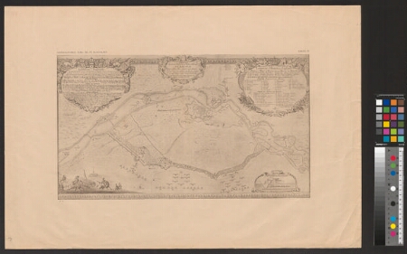
| Title | Geometrisk och accurat Delineation af Staden och ästningen Narwa. |
|---|---|
| Map type | Subsheet |
| Reference code | EAA.1646.1.2646 sheet 3 |
Belongs to main sheet
EAA.1646.1.2646 sheet 1
Cartographical and Publishing Description
| Main subject | military |
|---|---|
| Material designaton | plan |
| Manuscript/Printed | manuscript copy |
| Created | 20. saj I pool |
Components and Mathematical Description
| Components | legend for symbols, compass |
|---|---|
| Azimuth | Not set |
| Textual scale | 4 Reini ruutu on 6,8 cm |
| Relative scale | Not set |
Geographical Description
| Admin unit | Specification |
|---|---|
| Estonia (to 1917) / Estonia Guberniya / Viru County / Vaivara Parish | Narva |
Physical Description
| Storage form | rolled |
|---|---|
| Material and mounting | paper |
| Medium | photo |
| Dimensions (cm) | 74x50/A1 |
| Access-restrictions | No access restriction |
Maps referred to by this map
| Reference code | Relation |
|---|---|
| EAA.1646.1.2646 sheet 1 | duplicate |