Detailed description
To view the map area,
sign in or create account
sign in or create account
24.40 59.43, 24.47 59.47
Identity Description
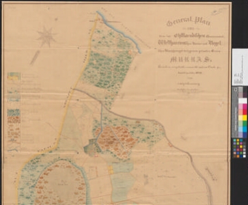
| Title | General-Plan von dem im Ehstlaendischen Gouvernement, Westharrienschen Kreise und Kegelschen Kirchspiele belegenen privaten Gutes Murras |
|---|---|
| Map type | Single sheet map |
| Reference code | EAA.3724.4.2120 sheet 1 |
Creators
| Firstname | Lastname | Occupation of cartographer | Creators position |
|---|---|---|---|
| Adolph | Grünberg | author of base map |
Cartographical and Publishing Description
| Main subject | Not set |
|---|---|
| Material designaton | plan |
| Manuscript/Printed | manuscript copy |
| Base map(s) year | 1848 |
| Created | 19. saj II pool |
Components and Mathematical Description
| Components | legend for symbols, compass, graphical scale |
|---|---|
| Azimuth | 30 |
| Textual scale | Maasstab 300 Faden = 15,2 cm |
| Relative scale | 4200 |
Geographical Description
| Admin unit | Specification |
|---|---|
| Estonia (to 1917) / Estonia Guberniya / Harju County / Keila Parish / Muraste Manor |
Physical Description
| Storage form | ümbrik |
|---|---|
| Material and mounting | paper |
| Medium | diazography+coloured |
| Dimensions (cm) | 125x91/2A0 |
| Access-restrictions | No access restriction |