Detailed description
To view the map area,
sign in or create account
sign in or create account
27.69 59.24, 27.93 59.40
Identity Description
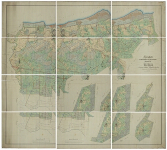
| Title | Specialkarte von dem Bauerpachtlande und einem Theile des Hofslandes zum privaten Gute Waiwara im Gouvernement Ehstland und Wierländischen Kreise belegen. |
|---|---|
| Map type | Single sheet map |
| Reference code | EAA.3724.4.1805 sheet 19 |
Creators
| Firstname | Lastname | Occupation of cartographer | Creators position |
|---|---|---|---|
| Gustav Moritz | Gnadeberg | Järva kreisimaamõõtja | cartographer |
Cartographical and Publishing Description
| Main subject | Not set |
|---|---|
| Material designaton | plan |
| Manuscript/Printed | manuscript original |
| Created | 1868 |
Components and Mathematical Description
| Components | compass, graphical scale |
|---|---|
| Azimuth | Not set |
| Textual scale | Maasstab von 500 Faden oder 1 Werst = 10 Zoll |
| Relative scale | 4200 |
Geographical Description
| Admin unit | Specification |
|---|---|
| Estonia (to 1917) / Estonia Guberniya / Viru County / Vaivara Parish / Vaivara Manor |
Physical Description
| Storage form | rolled |
|---|---|
| Material and mounting | paper+textile |
| Medium | ink+coloured |
| Dimensions (cm) | 190x184/>4A0 |
| Access-restrictions | No access restriction |