Detailed description
To view the map area,
sign in or create account
sign in or create account
27.31 57.51, 28.08 58.08
Identity Description
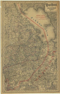
| Title | Petseri maakonna kaart |
|---|---|
| Map type | Multiple-sheet map |
| Reference code | EAA.5392.1.206 sheet 1 |
Subsheets
| Reference code |
|---|
| EAA.5392.1.206 sheet 1p |
| EAA.5392.1.206 sheet 2 |
| EAA.5392.1.206 sheet 3 |
Cartographical and Publishing Description
| Main subject | Not set |
|---|---|
| Material designaton | plan |
| Manuscript/Printed | printed |
| Created | 1920 (Estimated) |
Components and Mathematical Description
| Components | legend for symbols, grid lines |
|---|---|
| Azimuth | Not set |
| Textual scale | 6 versta = 5 cm |
| Relative scale | 126000 |
Geographical Description
| Admin unit | Specification |
|---|---|
| Estonia (1917-1950) / Petseri County (1919-1944) | Petseri mk |
Physical Description
| Storage form | streched |
|---|---|
| Material and mounting | paper |
| Medium | printed |
| Dimensions (cm) | 72x46/A1 |
| Access-restrictions | No access restriction |