Detailed description
To view the map area,
sign in or create account
sign in or create account
23.50594 57.75, 28.20911 59.46737
Identity Description
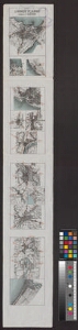
| Title | Linnade plaanid [Tallinn, Haapsalu, Paldiski, Pärnu, Paide, Rakvere, Viljandi, Tartu, Põltsamaa, Võru, Valga, Petseri, Narva, Narva-Jõesuu] |
|---|---|
| Map type | Single sheet map |
| Reference code | EAA.2072.10.122 sheet 1 |
Cartographical and Publishing Description
| Main subject | Not set |
|---|---|
| Material designaton | map |
| Manuscript/Printed | printed |
| Created | 1928 |
Components and Mathematical Description
| Components | Not set |
|---|---|
| Azimuth | Not set |
| Relative scale | 50000 |
Geographical Description
| Admin unit | Specification |
|---|---|
| Estonia (1917-1950) / Tallinn City/Town (1917-1950) | |
| Estonia (1917-1950) / Haapsalu City/Town (1917-1950) | |
| Estonia (1917-1950) / Paldiski City/Town (1917-1950) | |
| Estonia (1917-1950) / Pärnu City/Town (1917-1950) | |
| Estonia (1917-1950) / Paide City/Town (1917-1950) | |
| Estonia (1917-1950) / Rakvere City/Town (1917-1950) | |
| Estonia (1917-1950) / Viljandi City/Town (1917-1950) | |
| Estonia (1917-1950) / Tartu City/Town (1917-1950) | |
| Estonia (1917-1950) / Põltsamaa City/Town (1926-1950) | |
| Estonia (1917-1950) / Võru City/Town (1917-1950) | |
| Estonia (1917-1950) / Valga City/Town (1917-1950) | |
| Estonia (1917-1950) / Petseri City/Town (1919-1944) | |
| Estonia (1917-1950) / Narva City/Town (1917-1950) | |
| Estonia (1917-1950) / Narva-Jõesuu Borough (1919-1934) |
Physical Description
| Storage form | streched |
|---|---|
| Material and mounting | paper |
| Medium | printed |
| Dimensions (cm) | 110x17/A0 |
| Access-restrictions | No access restriction |