Detailed description
To view the map area,
sign in or create account
sign in or create account
23.92 58.27, 24.09 58.50
Identity Description
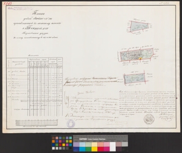
| Title | Планъ усадьбы Вайно nr. 146 принадлежащей къ частному имению Тестама Перновскаго уезда |
|---|---|
| Map type | Single sheet map |
| Reference code | EAA.2486.3.231 sheet 1 |
Creators
| Firstname | Lastname | Occupation of cartographer | Creators position |
|---|---|---|---|
| W. | Peters | Liivimaa rüütelkonna maamõõtja | cartographer |
Cartographical and Publishing Description
| Main subject | farm map |
|---|---|
| Material designaton | plan |
| Manuscript/Printed | manuscript duplicate |
| Base map(s) year | 1867-68 |
| Created | 1894 |
Components and Mathematical Description
| Components | explication, graphical scale |
|---|---|
| Azimuth | Not set |
| Textual scale | 1300 küünart = 15,2 cm |
| Relative scale | 5200 |
Geographical Description
| Admin unit | Specification |
|---|---|
| Estonia (to 1917) / Livonia Guberniya / Pärnu County / Tõstamaa Parish / Tõstamaa Manor |
Physical Description
| Storage form | Not set |
|---|---|
| Material and mounting | paper |
| Medium | ink+coloured |
| Dimensions (cm) | 66x48/A1 |
| Access-restrictions | No access restriction |